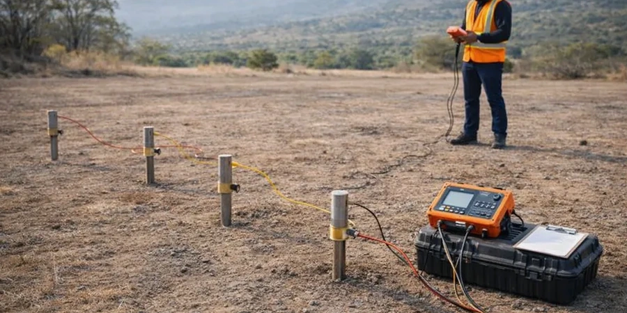
The field crew deploys a linear array of stainless-steel electrodes across a reclaimed colliery site near the M1 corridor, each pin driven precisely into the damp topsoil. A resistivity meter housed in a rugged yellow Pelican case cycles through pre-programmed Wenner and Schlumberger configurations, injecting a controlled DC current into the ground while measuring the resulting potential difference. The instrument's internal multiplexer switches electrode pairs automatically as the survey line extends, building a vertical resistivity profile that reveals how the subsurface responds to electrical current at increasing depths. Across Barnsley, where Carboniferous Coal Measures alternate with sandstone aquifers and pockets of glacial till, resistivity imaging provides the contrast resolution that conventional borehole drilling alone cannot deliver, mapping void spaces, water-filled fractures, and the boundary between weathered rockhead and competent strata in a single field session.
Electrical resistivity contrast between air-filled mining voids and water-saturated Coal Measures strata routinely exceeds 20:1, making VES the most diagnostic geophysical method for abandoned mine working assessment in South Yorkshire.
Our approach and scope
Barnsley sits at roughly 120 metres above ordnance datum on the undulating Pennine fringe, a town shaped by centuries of deep mining that left behind a labyrinth of abandoned shafts, collapsed headings, and unrecorded pillar-and-stall workings within the Middle Coal Measures. The local geology creates precisely the electrical contrast that Vertical Electrical Sounding exploits: dry, air-filled voids exhibit resistivity values exceeding 1,000 ohm-metres, while water-saturated drift or unconsolidated made ground typically measures below 50 ohm-metres. Our VES acquisition follows BS 5930 and Eurocode 7 (BS EN 1997-2:2007) guidelines, using maximum current electrode half-spacings of 150 to 250 metres to achieve investigation depths beyond 50 metres—critical where mine entries are known to descend through the Barnsley Seam. The resulting apparent resistivity curves undergo iterative inverse modelling to generate true layer thicknesses and resistivities, a process that distinguishes competent sandstone roof strata from collapsed zones where
seismic refraction might struggle with velocity inversions. For projects requiring continuous lateral coverage rather than single-point soundings, 2D electrical resistivity tomography lines can be combined with
test pits to calibrate the geophysical interpretation against direct observation of shallow fill composition.
Local ground factors
A developer preparing foundations for a multi-storey residential block on Sheffield Road encountered a legacy mine shaft cap recorded on 1890s abandonment plans but never physically verified. The planning authority's coal mining risk assessment required geophysical confirmation before releasing building control approval. A grid of Vertical Electrical Soundings centred on the suspected shaft location revealed a sharply defined low-resistivity anomaly at 18 metres depth, consistent with a collapsed, water-filled shaft column penetrating the Ackton Rock sandstone. The resistivity signature allowed the structural engineer to position the piled foundation to avoid the exclusion zone entirely, eliminating the need for costly shaft drilling and pressure grouting. Barnsley's Coal Authority dataset identifies over 1,400 mine entries within the borough boundary, and the majority lack precise surface coordinates—a situation where relying solely on desk study records creates unacceptable residual risk for any structure exceeding two storeys.
Quick answers
What depth can resistivity testing reach in Barnsley's geology?
With a maximum current electrode half-spacing of 250 metres, a single Vertical Electrical Sounding can resolve layer boundaries to approximately 60–80 metres depth in the Coal Measures sequence. The practical depth of investigation depends on the resistivity contrast between layers and the available space for electrode deployment. In urban Barnsley sites where space is constrained, we typically achieve 30–40 metres penetration, sufficient to evaluate the Barnsley Seam and overlying strata for mine working hazards.
How much does a resistivity survey cost for a typical Barnsley residential development?
A VES-based mine entry investigation on a standard residential plot in Barnsley typically falls between £540 and £800, depending on the number of soundings required and the complexity of the site access. This includes data acquisition, inverse modelling, interpretation against Coal Authority records, and a factual report with resistivity cross-sections and mine working risk commentary.
Can resistivity testing distinguish between a water-filled void and intact saturated sandstone?
Distinguishing between water-filled voids and saturated sandstone is challenging because both can exhibit resistivities in the 30–80 ohm-metre range. The interpretation relies on contextual geological evidence: a water-filled shaft typically appears as a discrete sub-vertical low-resistivity anomaly, whereas saturated sandstone forms a laterally continuous layer. We resolve this ambiguity by acquiring multiple parallel ERT lines and comparing the anomaly geometry with known Coal Measures stratigraphy and historical mine abandonment plans.