Barnsley's built form tells a story of steep cuts and reclaimed land. The town grew fast through coal and glass, leaving a landscape where terraced streets climb sharply from the Dearne Valley and old pit mounds were reshaped into retail parks and housing estates. Every time a contractor opens a cut on Sheffield Road or terraces into the slope behind Pogmoor, the ground reacts differently depending on what lies beneath — sandstone, shale, or backfilled colliery spoil. Our lab team runs triaxial consolidated-undrained tests to pin down effective stress parameters because these residual soils don't behave like textbook materials. When we tie those numbers into limit equilibrium models, the factor of safety often drops below what a desktop study would suggest. We've seen it enough times to know that Barnsley doesn't forgive assumptions.
Barnsley's weathered mudstones lose up to 60% of their peak shear strength with just 3% moisture increase — that's the difference between a stable 26° slope and a creeping failure.
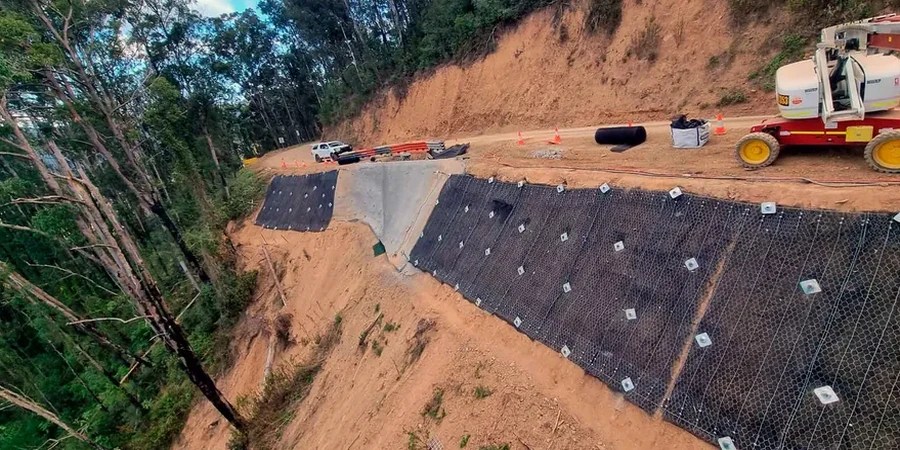
Our approach and scope
The contrast between a site near Locke Park and one up toward Dodworth is instructive. Locke Park sits on relatively shallow drift over Coal Measures sandstone — decent bearing, moderate permeability, predictable in the dry season. Dodworth, on the other hand, brings you into Pennine Lower Coal Measures with thin-bedded mudstones, seatearths, and old shallow workings that leave voids and softened zones well below the weathering profile. We run
atterberg limits on the weathered mudstone fraction because plasticity indices above 25% here correlate strongly with progressive creep on even gentle slopes. For the Dodworth-type profile, we also pull in
masw profiles to map the shear wave velocity contrast at the weathering front — that boundary often becomes the failure surface when saturation spikes after heavy winter rain. It's not one-size-fits-all geotechnics; it's comparing two postcodes 15 minutes apart and getting fundamentally different ground models.
Quick answers
What does a slope stability analysis for a Barnsley site typically cost?
For a single cut slope or embankment with site investigation data already available, budget between £870 and £3,140 depending on the number of cross-sections, groundwater scenarios, and whether seismic loading is required. If we need to run the lab testing programme as well (triaxial or direct shear), that adds cost but gives you defensible input parameters rather than textbook estimates.
How long does the analysis take from receiving the ground investigation data?
A straightforward single-section LEM analysis with two groundwater scenarios typically delivers within five working days. Complex sites with multiple cross-sections, sensitivity runs, or remediation iterations take seven to ten working days. We can expedite to three days for urgent planning committee deadlines — just flag it when you send the borehole logs.
Do you account for old mine workings in the slope model?
Yes, explicitly. Where the Coal Authority data or site investigation confirms shallow abandoned workings within the slope profile, we model void zones as low-strength bands or incorporate crown-hole collapse scenarios into the limit equilibrium search. The Coal Measures beneath Barnsley have been worked for centuries — ignoring that history in a slope model is a design error we simply will not make.
What factor of safety do you target for permanent slopes?
We design to BS EN 1997 Design Approach 1 Combination 2, which requires a minimum factor of safety of 1.50 for permanent slopes under static conditions. For temporary works with a design life under 12 months, we accept 1.30 provided the groundwater assumptions are conservative. Seismic cases are checked at 1.10 minimum per the UK National Annex to Eurocode 8.